Process Lidar Datasets
WARNING auKsys/5 has been released as stable, but this documentation has not been fully updated with changes since auKsys/4. In case of questions or mistakes, you can use the support project.
In this tutorial we are going to learn how to use pralin/compose to process lidar data stored in a kDB dataset. We will see how to iterate over the lidar data frames, combines them in a new dataset and then how to downsample the point cloud.
We will use a kDB store for the purpose of that tutorial, lets start it with:
kdb store --path tuto_kdb_store --extension kDBSensing
We will use the dataset of lidar data acquired near the buildings of the Gränsö castle. It can be downloaded and uncompressed with the following command:
curl -o lidar_buildings.kdb_dataset.xz "https://gitlab.liu.se/lks/tutorials_data/-/raw/main/lidar_buildings.kdb_dataset.xz?ref_type=heads&inline=false"
xz -d lidar_buildings.kdb_dataset.xz
The dataset can be imported into the database using the following command:
kdb datasets import --path tuto_kdb_store --filename lidar_buildings.kdb_dataset
Combine lidar frames into a single point cloud
This composition will query a database for a 3D lidar scans (for instance, from a velodyne/ouster sensor). It will combine the scans into a single point cloud, and write it down in a file:
compose:
  parameters:
    kdb_host: !required null
    kdb_port: 1242
    source_dataset_uri: !required null
    output_filename: !required null
  process:
    # This create a connection to the kDB database, according to the parameter `kdb_host`
    # and `kdb_port`
    - kdb/create_connection_handle:
        id: connection
        parameters:
          host: !param kdb_host
          port: !param kdb_port
    # This start a query for a lidar 3D scan dataset, using the connection and the dataset
    # specified in parameters
    - kdb/sensing/query_lidar3d_scan_dataset:
        id: qid
        inputs: ["connection[0]"]
        parameters:
          query: !param source_dataset_uri
    # Create a transformation provider using the proj library for handling geographic
    # transformations.
    - proj/create_transformation_provider:
        id: ctp
    # This loop over the scans in the dataset
    - for_each:
        id: iterate_scan
        iterator: qid[0]
        process:
          # This accumulate the points, note that the first input is initialized
          # with a `default` point cloud, which is an empty point cloud, and then
          # it is connected to the output of combine for iteratively building the
          # point cloud
          - pcl/combine:
              id: combine
              inputs: [ [default, "combine[0]"], "iterate_scan[0]", "ctp[0]" ]
    # This will output the point cloud to a file
    - pcl/pcd_writter:
        inputs: [ !param output_filename, "combine[0]"]
When using the Gränsö dataset, and the tuto_kdb_store database, the composition can be started with:
pralin compose --parameters "{ kdb_host: 'tuto_kdb_store', source_dataset_uri: 'http://askco.re/examples#lidar_granso', output_filename: 'test.pcd' }" --
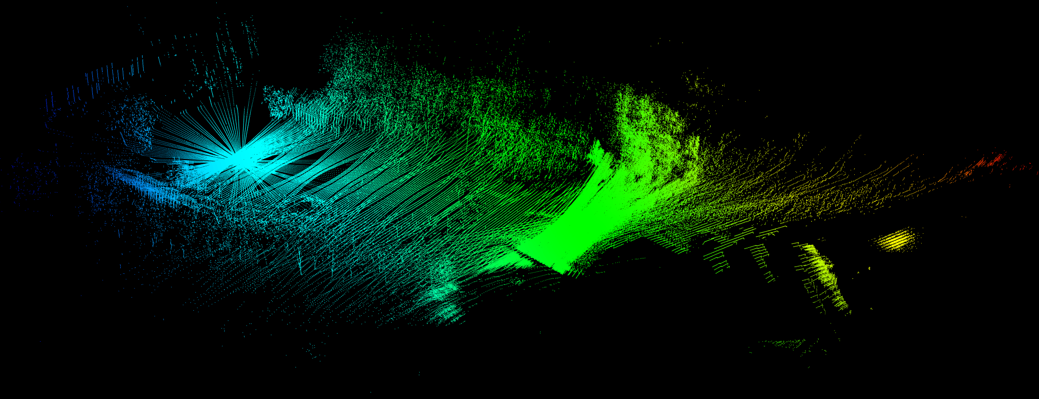
After running the composition, the file can be visualized with pcl_viewer (from the pcl-tools package):
pcl_viewer test.pcd
This should lead to an image similar to:

Downsample point cloud
This composition is similar to the previous one, but it includes a downsampling step:
compose:
  parameters:
    kdb_host: !required null
    kdb_port: 1242
    source_dataset_uri: !required null
    output_filename: !required null
  process:
    # This create a connection to the kDB database, according to the parameter `kdb_host`
    # and `kdb_port`
    - kdb/create_connection_handle:
        id: connection
        parameters:
          host: !param kdb_host
          port: !param kdb_port
    # This start a query for a lidar 3D scan dataset, using the connection and the dataset
    # specified in parameters
    - kdb/sensing/query_lidar3d_scan_dataset:
        id: qid
        inputs: ["connection[0]"]
        parameters:
          query: !param source_dataset_uri
    # Create a transformation provider using the proj library for handling geographic
    # transformations.
    - proj/create_transformation_provider:
        id: ctp
    # This loop over the scans in the dataset
    - for_each:
        id: iterate_scan
        iterator: qid[0]
        process:
          # This accumulate the points, note that the first input is initialized
          # with a `default` point cloud, and we connect to the downsampler for
          # optimization purposes.
          - pcl/combine:
              id: combine
              inputs: [ [default, "downsample[0]"], "iterate_scan[0]", "ctp[0]" ]
          # Downsample the point cloud to not contain more than 1 pts per 1m boxes.
          - pcl/downsample:
              id: downsample
              inputs: ["combine[0]"]
              parameters:
                x: 1
                y: 1
                z: 1
    # This will output the point cloud to a file
    - pcl/pcd_writter:
        inputs: [ !param output_filename, "downsample[0]"]
Store the point cloud in the database
In this composition, instead of saving the resulting point cloud in a file. We will save it as a new dataset in the kDB store:
compose:
  parameters:
    kdb_host: !required null
    kdb_port: 1242
    source_dataset_uri: !required null
    destination_dataset_uri: !required null
  process:
    # This create a connection to the kDB database, according to the parameter `kdb_host`
    # and `kdb_port`
    - kdb/create_connection_handle:
        id: connection
        parameters:
          host: !param kdb_host
          port: !param kdb_port
    # Query the source dataset
    - kdb/datasets/get:
        id: source_dataset
        inputs: ["connection[0]"]
        parameters:
          query: !param source_dataset_uri
    # Create the dataset, as a subdataset from the source dataset, we use a source
    # dataset, and will reuse the geometry defined by the source.
    # However, we need to change the type from `http://askco.re/sensing#lidar3d_scan`
    # to `http://askco.re/sensing#point_cloud`.
    # We specify as parameter `destination_dataset_uriW.
    - kdb/datasets/create:
        inputs: ["connection[0]", "source_dataset[0]"]
        parameters:
          uri: !param destination_dataset_uri
          type: http://askco.re/sensing#point_cloud
    # This start a query for a lidar 3D scan dataset, using the connection and the dataset
    # specified in parameters
    - kdb/sensing/query_lidar3d_scan_dataset:
        id: qid
        inputs: ["connection[0]"]
        parameters:
          query: !param source_dataset_uri
    # Create a transformation provider using the proj library for handling geographic
    # transformations.
    - proj/create_transformation_provider:
        id: ctp
    # This loop over the scans in the dataset
    - for_each:
        id: iterate_scan
        iterator: qid[0]
        process:
          # This accumulate the points, note that the first input is initialized
          # with a `default` point cloud, and we connect to the downsampler for
          # optimization purposes.
          - pcl/combine:
              id: combine
              inputs: [ [default, "downsample[0]"], "iterate_scan[0]", "ctp[0]" ]
          # Downsample the point cloud to not contain more than 1 pts per 1m boxes.
          - pcl/downsample:
              id: downsample
              inputs: ["combine[0]"]
              parameters:
                x: 1
                y: 1
                z: 1
    - kdb/sensing/insert_point_cloud_in_dataset:
        inputs: [ "connection[0]", "downsample[0]"]
        parameters:
          query: !param destination_dataset_uri